Waikato Regional Council has responsibilities for managing flood risk in the Waikato region.
While flood protection schemes have been built where river flooding historically caused significant damage to productive farmlands, large communities or towns, major transport routes and critical infrastructure, there are also other ways we manage floods to protect people and property.
This includes flood forecasting, an automated regional flood warning system, and emergency management.
Forecasting
Waikato Regional Council maintains an overview of key river systems, weather patterns and forecasts affecting the Waikato region.
When MetService issues severe weather alerts or forecasts that could impact river flooding, our flood protection schemes and our communities, we closely monitor the situation, connect with keys teams to understand catchment condition and use our environmental data to then provide information on the potential impacts to supporting agencies (such as civil defence, local councils and NZ Transport Agency Waka Kotahi) to assist with planning and response.
We have automated recorder sites around the region that constantly check river levels and rainfall every 15 minutes, with the data sent electronically to our Hamilton office.
During storm events, we track river levels to see how quickly they’re rising. We also keep an eye on how much rain is falling to help us predict how much the river levels may rise by and to estimate how much more water the land can soak up.
Alerts are activated by heavy rainfall and rising river levels at over 50 automated monitoring sites. These alerts, which are configured with different severities, notify the right people via multiple channels, and help us to coordinate an appropriate flood response and warn communities.
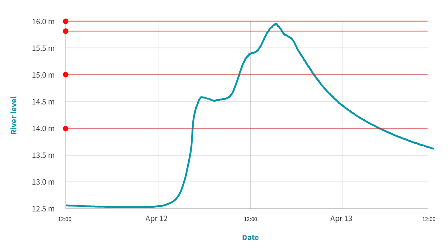
Our river level recorder for the Ohinemuri River at Karangahake Gorge has the following alerts: at river level 14m a flood response is activated; at river level 15m, agencies are informed so they can prepare for closure of the gorge; at river level 15.8m, the gorge is closed; and at river level 16m, the Criterion Bridge floodgates across SH26, at Paeroa, are closed.
Understanding your risk
River flooding is a frequent event in the Waikato region for the following reasons.
- The region is susceptible to storms of tropical origin.
- Our many steep, short, river catchments get intense, localised rainfall, which is difficult to forecast.
- The region has large river systems, as well as large areas of low-lying flood plains near sea-level that are intensely farmed or developed.
- We have large areas of land that lack vegetation cover, which increases run-off and erosion.
River flooding is more likely to occur when:
- heavy rain runs off already saturated soils
- a river channel is no longer able to hold the volume of water
- damaged or poorly constructed stop banks fail to hold floodwaters back
- drains (such as storm water drains) are blocked by debris
- there is a high tide or king tide, increasing water levels in rivers that flow into the sea.
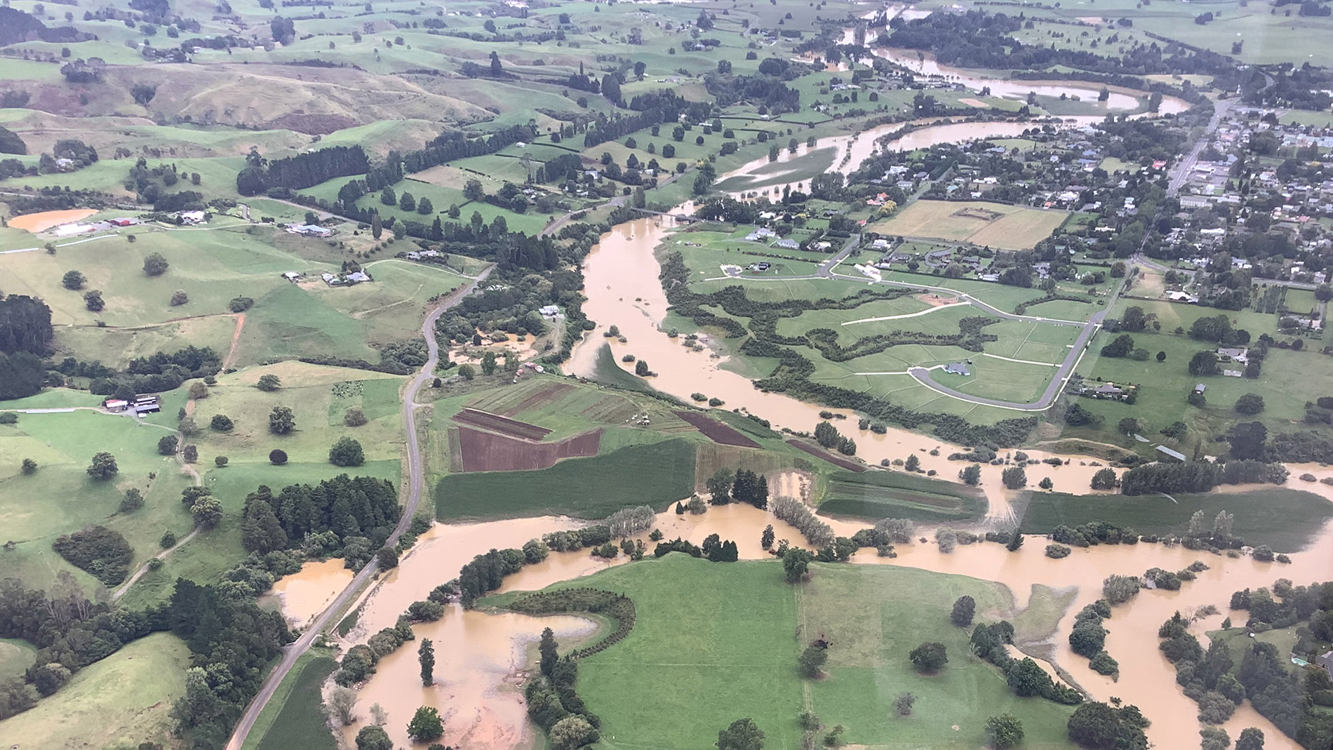
Our main river hazard areas are:
- the Coromandel Peninsula, due to its short steep catchments (the rain quickly runs into the rivers) and susceptibility to tropical storms – water levels rise very quickly, with little time for warning and preparation
- the Hauraki Plains, where low lying farmland and towns are vulnerable to flooding along the Waihou and Piako river systems
- farmland adjacent to the Waipā River, especially since water levels in this river is not controlled by dams
- the lower Waikato River, from where the Waipā River joins the Waikato River at Ngāruawāhia all the way to Port Waikato
- at the southern end of Lake Taupo, where the Tongariro and Tauranga-Taupō rivers enter the lake.
With the effects of climate change, we are seeing more heavy rainfall and flooding in the west of the region and in river catchments in the Coromandel Peninsula. Increased sea levels (due to sea level rise) will also increase the risk of river flooding in rivers where they drain to the sea.