
2023 Waikato projections
The 2023 based Waikato land use, population, household, employment and economic projections will be updated following the 2023 Census, at regional, district and local areas (SA2) level.
2018 Waikato projections
The Waikato Projections for 2018-2068 are based on the 2018 census data and were completed at the end of March 2021. The Waikato projections project initially develops data at a TA level for several parameters (i.e. population - Figure 1). Further modelling work then provides outputs for the key parameters down to a Statistical Areas 2 unit level (SA2).
Figure 1: process for development of SA2 level projections - links between three modelling work streams
The following parameter outputs are modelled by SA2:
- Land use
- Population
- Households
- Workforce
- Employment
- Value added
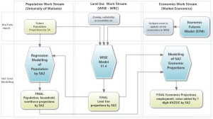
These parameters are generated using three different modelling processes (Figure 2). The WISE model is used to generate projections of future land use by SA2. This land‑use information is then used in two other modelling processes (Demographics by the University of Waikato, Economics by Market Economics Ltd) to provide the other parameters at an SA2 level.
The strength of this approach is that the key known drivers of future land‑use change (projected Territorial Authority (TA) population growth, district plan zoning, planned infrastructure, geophysical suitability, etc.) are all used in projecting future land‑use change in WISE. This land‑use information can then be used to directly influence the allocation of population and associated economic activity at an SA2‑level through additional modelling.