Coverage of protected freshwater wetlands
Why we monitor protection of freshwater wetlands
Waikato Regional Council monitors changes in the amount and proportions of freshwater wetland that is in some form of legal protection, including government reserves and private protected land.
This indicator reports on what wetland types are best protected, who is protecting them, and where they are protected.
The Waikato Regional Policy Statement has a policy to provide for (among other things) the promotion of voluntary legal protection, restoration or enhancement of indigenous biodiversity.
Wetlands are a severely depleted and often degraded ecosystem type. Nationally, an estimated 90 per cent of the pre-human extent of wetlands has been cleared and drained.
Legal protection in a gazetted reserve or other legal instrument is one method to protect wetlands and their associated biodiversity from deliberate destruction.
In New Zealand, legally protected areas can be on publicly or privately owned land, and include:
- Department of Conservation reserves
- QEII covenants (private protected land)
- Ngā Whenua Rāhui Kawenata (protected Māori-owned land)
- other areas protected by territorial authorities or state-owned land.
Some areas are legally protected for the express purpose of protecting natural features from deliberate destruction or development. In other cases, land has been set aside for another purpose, e.g. for recreation or future use for cemeteries or other public amenity. If such land has been gazetted under the Reserves Act, there is a secondary requirement to protect natural features in that parcel, to the extent compatible with the reserve’s stated purpose.
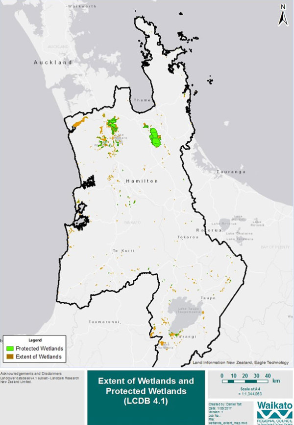
Waikato Regional Council has analysed the extent of freshwater wetlands in the region (including those dominated by invasive deciduous trees) that are in a form of legal protection (for example gazetted as a reserve or identified as an open space covenant on land title). We also analyse protection of wetlands within bioclimatic zones and within National Priority 1 Environments.
Monitoring trends in the type, location, and extent of protected wetland areas gives us valuable information on how much protection we are giving to our region's unique biodiversity and whether our reserves network is representative across wetland type and geographic spread.
Monitoring protected wetlands helps us to:
- assess overall progress of the total area protected, as a measure of policy response to biodiversity loss
- track changes in extent of protected areas in relation to geographical and political units, and to different measures of biodiversity (such as priority areas, ecosystem or habitat maps and species distributions)
- ensure a full range of habitats are protected to maintain biodiversity
- find out what geographic areas or wetland types are under-represented in the current reserves system.
- identify priority areas for conservation.
The monitoring outcomes can therefore guide adaptive management and policy decisions for biodiversity management planning.
What's happening?
The current (as of 2022) extent of freshwater wetland in the Waikato Region is 33,269 hectares, covering approximately 1.4 per cent of the region’s total land area.
In total, 55 per cent of the region’s remaining freshwater wetlands are in some form of legal protection.
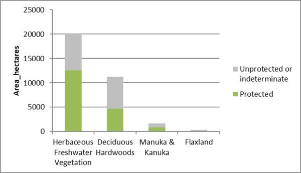
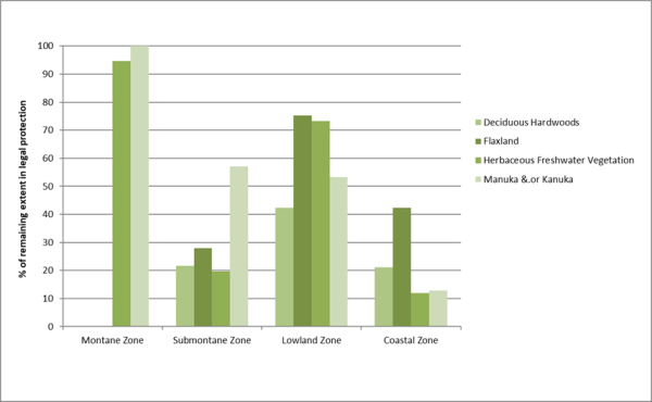
Reserves currently protect 63 per cent of the total current extent of Herbaceous Freshwater Vegetation, 42 per cent of the Flaxland, 53 per cent of wet Manuka &/or Kanuka, and 42 per cent of the wet Deciduous Hardwood forest.
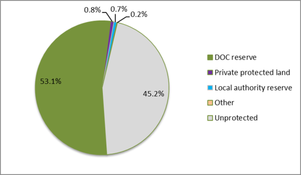
Department of Conservation reserves account for over 97 per cent of the protected freshwater wetlands, while private protected land and district council reserves each hold just over 1 per cent of the total amount of protected freshwater wetlands.
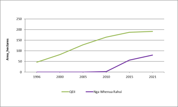
Every year since 1996, an average of 9 hectares of privately owned freshwater wetland in the region has been protected under QEII covenants or Nga Whenua Rahui kawenta. As of January 2021, a total of 272 hectares of freshwater wetland were protected on private land.
Over 83 per cent of all of the remaining areas of freshwater wetland in the Waikato Region occur within National Priority 1 Environments. Across the region almost over 10,550 hectares of freshwater wetland remain unprotected in these threatened environments.
Freshwater wetlands occur mostly in lower elevations, with 85 per cent of the current extent found in the lowland bioclimatic zone of which 61 per cent is protected. Wetlands in submontane and coastal areas are the least well-protected with less than a quarter of their remaining wetlands in some form of reserve or on private protected land.
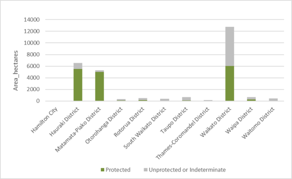
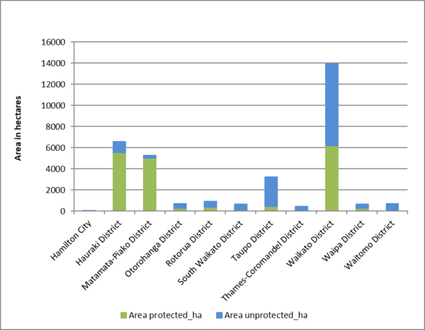
Within the district council areas, Matamata-Piako, and Hauraki districts have the highest proportion of their remaining wetland areas protected (more than 80 per cent). One third of the Region’s total area of unprotected freshwater wetlands lies in the Taupo and Waikato district council areas.
Results - data and trends
This Excel spreadsheet contains the source data for this indicator's graph and information.

Methods - how we monitor
More information
When this indicator is updated
Updates will happen as new (region-wide) vegetation/cover spatial layers become available. It is estimated that this will be updated every five years.
Last updated July 2022
Footnotes
- Ausseil A-G, Gerbeaux P, Chadderton WL, Stephens T, Brown D, Leathwick J 2008. Wetland ecosystems of national importance for biodiversity: criteria, methods and candidate list of nationally important inland wetlands. Landcare Research Contract Report LC0708/158. 174 p
- Ministry for the Environment & Department of Conservation 2007. Protecting our Places: Information about the statement of national priorities for protecting rare and threatened biodiversity on private land. Wellington, Ministry for the Environment & Department of Conservation