Why we monitor condition of aquatic plant communities
Lakes are an important resource from an ecological and recreational perspective and their values contribute to the biodiversity of the Waikato region. For example, the peat lakes of the region are nationally significant and represent a habitat which has a limited extent throughout New Zealand.
Waikato Regional Council holds the legislative mandate to protect and improve water quality in lakes. The Resource Management Act 1991 gives regional councils responsibilities to control land use in order to maintain and enhance water quality and quantity. Under section 39 (e) of the Act, Waikato Regional Council controls the taking, use, damming and diversion of water as well as the quantity, level and flow of water into any water body. The council also controls discharges into water.
The Regional Policy Statement also places emphasis on protection and improvement of water quality within lakes.
Assessment of aquatic plant communities in lakes can help provide additional information to other techniques that are currently used.
What's happening?
The LakeSPI method, developed by NIWA, has been used in the current assessments. The method can provide a valuable tool in monitoring these impacts and can be used by lake managers to:
- assess and compare the ecological condition of different lakes within the Waikato region
- look at longer term trends in lake health
- compare current lake condition with values that have been generated from historical vegetation records
- make comparisons between dissimilar lakes
- aid in assessing how effective catchment and management initiatives and policies are
This indicator presents results obtained using the LakeSPI technique. The indices calculated for each lake using the LakeSPI technique are:
- Native Condition Index reflects the native character of vegetation in a lake.
- Invasive Condition Index reflects the introduced (non native) character of vegetation in a lake.
- LakeSPI Index is a combination of parts of both the native condition and invasive condition indices and provides an overall indication of the lakes condition.
A key assumption of this method is that while a high native index represents a healthier condition, and a high exotic index represents an undesirable condition, the presence of good condition exotic plants is still preferable to total collapse and an algal dominated water column.
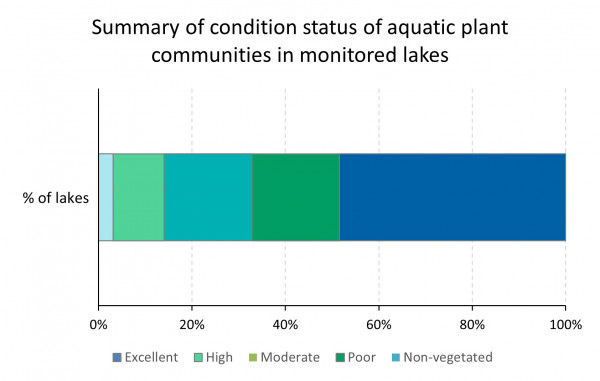
NIWA was asked to carry out a LakeSPI assessment on 64 Waikato lakes and categorise their condition as either:
- Excellent
- High
- Moderate
- Poor
- Unvegetated
These categories are presented in this indicator. Index values for individual lakes can be viewed on the data page.
The condition of aquatic plant communities in lakes within the Waikato region is generally 'non-vegetated’ – ‘moderate’. Two lakes meet the criteria outlined for ‘excellent condition’. Most of the 'non-vegetated’ – ‘moderate’ have undergone aquatic plant community collapse over recent years.
Methods - How we monitor
Results - data and trends
Download the data file
This Excel spreadsheet contains the source data to this indicator's graph and any additional data.
More information
The NIWA website can supply the results from these LakeSPI surveys as well as information for other lakes throughout the country. Their site also provides access to technical manuals and other information.
When this indicator is updated
This indicator is likely to be updated every 5 years or when required. The next survey will be undertaken in 2021.


