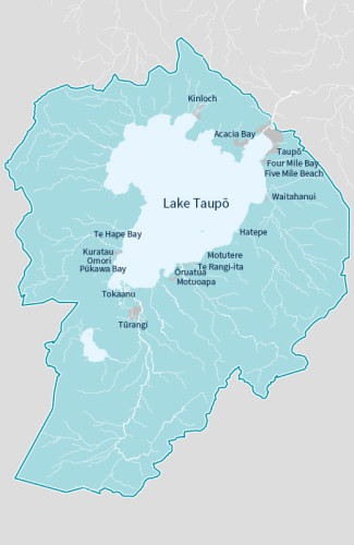
Collaboratively enhancing the health and wellbeing of rivers and catchments within the Lake Taupō zone.Located in the heart of the North Island, surrounding Lake Taupō, the Lake Taupō catchment covers an approximate area of 349,655ha (nearly 9 per cent of the Waikato region). Lake Taupō is the largest lake by surface area in New Zealand 61,491ha and comprises 17.5 per cent of the Lake Taupō catchment area. The catchment contains significant geothermal resources, 11 other smaller lakes, part of New Zealand’s oldest national park and dual World Heritage area, and significant hydroelectric schemes. The Lake Taupō Zone team works to identify issues that relate to our land, water and communities by integrating three key areas of work: river and catchment management, restoring biodiversity and pest plant/animal control. We are continuing to work alongside tangata whenua, iwi trusts, landowners and communities to undertake works across the zone. |
|
Lake Taupō zone plan
This plan sets the strategic direction for Waikato Regional Council’s integrated catchment management activities within the Taupō zone over the next 10 years.
Protecting our catchment and land management
Rivers and flood mitigation
On-going works - Tauranga-Taupō River
Waikato Regional Council maintains a flood protection scheme on the Tauranga-Taupō River. This scheme is designed to protect the communities of Te Rangiita and Oruatua from flooding up to a 1 in 50-year event.
Continued monitoring and maintenance of flood scheme assets, floodway and the river channel is required to ensure the scheme operates to its design during flood events.
You can find out more about this year's programme of works for the river in the document below.
