Why we monitor surface water availability
Waikato Regional Council monitors surface water availability to protect our region’s surface water resources. When too much surface water is taken from surface waterways:
- It reduces the ability of water bodies to assimilate contaminants from point and non-point sources. In relation to the Waikato River catchment this is inconsistent with giving effect to the overarching purpose of restoring and protecting the health and wellbeing of the Waikato River for present and future generations.
The individual and cumulative effects of the taking of water may;
- constrain the ability to protect and enhance the health and wellbeing of the Region's water bodies, and result in the degradation of water quality and aquatic habitat,
- impact on cultural relationships with the water bodies in the Region,
- limit the availability of water for other actual and potential uses,
- compromise the generation of electricity from renewable energy sources and cooling of the Huntly Power Station.
This indicator measures the amount of ‘available’ surface water for allocation in the Waikato region. We estimate the amount of stress on surface water resources by comparing the volume of ‘available’ surface water with the volume allocated for use.
The ‘available’ surface water is the total volume of water that can be taken within set allocation levels without negatively affecting the waterways. As more water is taken from surface water, the volume of ‘available’ water for future use drops. We estimate the level of stress on surface water resources by comparing the volume of ‘available’ water to the volume that’s already been allocated for use. The available water includes both the Primary and Secondary allocable flows as set in Table 3-5 of the Waikato Regional Plan.
What's happening?
Waikato Regional Council monitors ‘available’ levels of surface water to ensure surface water resources are used sustainably.
‘Available’ surface water is the total volume of water that can be taken within set allocation levels. As more water is taken from surface water, the volume of ‘available’ water for future use drops. We estimate the level of stress on surface water resources by comparing the volume of ‘available’ water to the volume that’s already been allocated for use. The available water includes both the Primary and Secondary allocable flows as set in Table 3-5 of the Waikato Regional Plan.
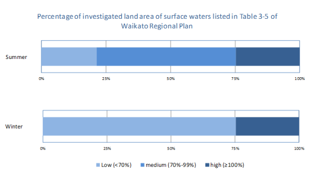
Waikato Regional Council divides the surface water resources we monitor in our region into three categories: low, medium and high stress.
- Low stress areas have less than 70 percent of available surface water allocated for use.
- Medium stress areas have between 70 and 99 percent of available surface water allocated for use.
- High stress areas have 100 percent or more of available surface water allocated for use.
Methods - How we monitor
Results - data and trends
Download the data file
This Excel spreadsheet contains the source data to this indicator's graph. The data were collected in 2015.
This indicator is updated every three years.


